Coordinate System: Define local coordinate system
Different coordinate systems can be defined to
be used later by commands like Sort, Smooth, 3D-Extension/Translation, Boundary conditions, Nodal loads . These coordinate systems are saved together
with the nodes of the macro and the FE model. In case a new structure is loaded
from hard disk they currently defined coordinate systems are maintained if they
are not overwritten by loaded systems with identical IDs. No longer needed
coordinate systems have to be deleted explicitly. The dialog shows the number of defined coordinate system.
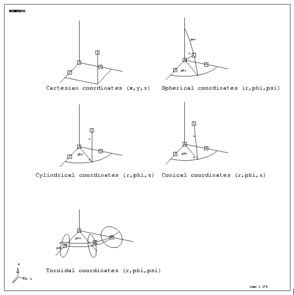
The orientation of coordinate systems is
defined by three nodes, which can be specified either by a node ID or by global
coordinates (x,y,z).
Node P1 defines the origin, P2 defines the
positive direction of the local x-axis and P3 defines a node somewhere within
xy-plane (except for „cylindrical2“ systems). The local z-axis is always set up
to build a right-handed cartesian coordinate system. Toroidal coordinate system
uses P2 as the origin, i.e. the distance P1-P2 defines the torus radius.
Following figure shows available coordinate systems and the
definition of these systems.
Following dialog shows the available options:
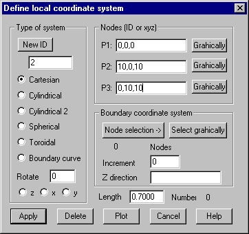
Type of
system
ID: Give
the ID of the coordinate system to be created or range of IDs for coordinate
systems to be deleted, plotted or rotated. Button “New ID” gets the next not
used ID.
Cartesian:
Cartesian system with coordinates x,y,z
Cylindrical:
Cylindrical system with coordinates r,j,z. Z-axis is perpendicular to plane
P1-P2-P3
Cylindrical:2 Cylindrical system with coordinates r,j,z. Direction P1-P2 builds z-axis,
P1-P3 build x-axis
Spherical:
Spherical system with coordinates r,j,f. P1 = center node.
Toroidal:
Toroidal system with coordinates r,j,f.
Boundary curve: This Option makes it possible to define multiple cartesian coordinate
systems tangential to a given curve, for example for the definition of
perpendicular or tangential loads or boundary conditions. The nodes of the
curve must be selected within “Node selection“ dialog or graphically. For each
node of the boundary curve the tangent vector is calculated. The x-axis of the
coordinate system is oriented towards this vector and perpendicular to the
given z-direction. The generated coordinate systems are numbered with the IDs
of the related nodes plus the given increment. There are a maximum number of
500 coordinate systems that can be stored.
Rotate:
This option makes it possible to alter the orientation of already defined local
coordinate systems. The axis about which should be rotated must be selected and
the angle of rotation must be given. The IDs of one or more defined coordinate
systems can be given.
Nodes (ID
or xyz):
Define points P1-P3 with node ID or global
coordinates.
P1: The
origin of the coordinate system.
P2: Node
on x-axis.
P3: Node
within xy-plane.
Graphically:
The node is to be selected within the OpenGL window. The coordinates of these
nodes will be updated within the corresponding input fields.
Boundary
coordinate systems
When
option “Boundary curve” is selected, the following additional parameters must
be given:
Node selection: Node selection dialog pops up to define nodes for the boundary curve.
The boundary curve is defined by all element nodes, which are contained within
this selection.
Select graphically: Nodes of boundary curve will be selected graphically.
Increment:
The increment for numbering the generated coordinate systems must be given (0
is allowed).
Z-direction: The direction of the z-axis of the local coordinate system must be
given. This direction must not be within the plane of the boundary curve.
Delete
One or
more coordinate systems are removed. The ID of the coordinate system or a range
of IDs for several coordinate systems to be deleted must be given.
Plot
This
button plots the coordinate systems who’s IDs are given. Also the length of the
axis must be given. ID 0 plots all coordinate systems. Newly defined systems
are automatically plotted.